Want to know what fruit, produce or other products are available in Green Bluff? Check out the Green Bluff fruit picking schedule.
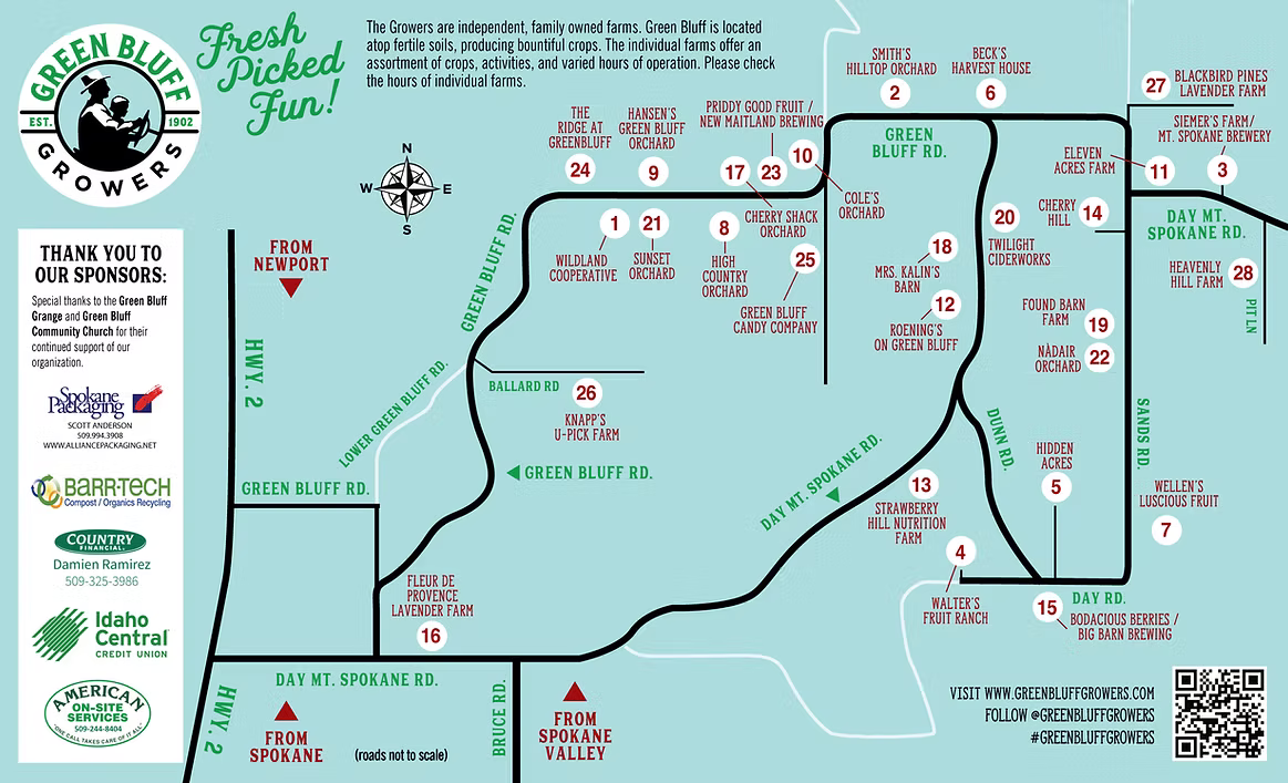 Map and Growers List provided courtesy of the Green Bluff Growers.
Your Essential Guide to the Green Bluff Map
Finding Your Way Around Green Bluff’s Farm Community
Planning a visit to Green Bluff, WA and its famous farming community? The Green Bluff map is your essential guide to discovering the abundance of family farms, orchards, and seasonal attractions that make this agricultural region a beloved destination just northeast of Spokane, Washington.
Understanding the East and West Loops
The well-marked map outlines both the East and West loops of Green Bluff, showcasing over 20 member farms that welcome visitors throughout the growing season. Each farm is clearly labeled on the map, making it easy to plan your route through this charming rural community. Whether you’re searching for Green Bluff pumpkins in fall or hoping to pick sun-ripened cherries in summer, you can locate exactly where to go for all your Green Bluff fruit and fun adventures!
Popular Farm Destinations
The West loop features popular destinations like High Country Orchard, famous for its fresh-baked pies and country store. Satisfy your sweet tooth with the Green Bluff Candy Company with locally made treats! Don’t forget about The Ridge at Green Bluff, with its manicured orchards and stunning wedding venue.
Meanwhile, the East loop leads you to beloved stops like Walters’ Fruit Ranch, where generations of families have enjoyed picking apples and riding the famous Apple Express during harvest season. Enjoy the farm store, country pizza, strawberries, and the annual corn maze at the historic Siemers Farm.
All that driving got you going nuts? Then head on over to the Promised Land Hazelnut Orchard, a rare find in Green Bluff. Head down the road to a tucked away location to Hidden Acres Farm, known for its stunning valley views and extensive U-pick options. After all you’re looping, head on into Big Barn Brewing for a cool local brew and some fun yard games!
Navigating with the Green Bluff Map
What makes this map particularly valuable is how it helps visitors understand the layout of this sprawling farming community. The map clearly shows how Green Bluff Road and Day Mt. Spokane Road connect, creating an easy-to-follow route between farms. You’ll find helpful markers indicating parking areas, restroom facilities, and picnic spots, ensuring your farm-hopping adventure is comfortable and convenient.
Seasonal Events and Activities
During peak seasons, such as the Cherry Pickers’ Trot race and fun run in early summer or the Apple Festival in fall, this map becomes invaluable for navigating between event locations. It helps visitors find participating farms and ensures they don’t miss any of the seasonal activities, from hay rides and corn mazes to craft vendors and live music venues.
Making the Most of Your Visit
For first-time visitors, this guide offers a comprehensive overview of Green Bluff’s layout, while returning visitors can use it to discover new farms they haven’t explored before. Whether you’re planning a full day of U-pick adventures, searching for fresh produce at farm stands, or exploring local wineries, the Green Bluff map is your trusted companion for making the most of your visit to this vibrant agricultural community.
Remember to download the Green Bluff map before you go. This way, you’ll have a reliable guide even in areas where mobile phone service might be spotty.
Green Bluff Real Estate
Interested in Green Bluff real estate? Search Green Bluff homes for sale or find Green Bluff land.